Saturday, August 28, 2010

Trails and Backcountry Camp Conditions
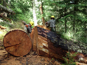


A large blowdown on the Wonderland Trail
The Trail Crew clearing a large tree from the Wonderland Trail
Mount Rainier can receive 700 or more inches of snow each winter. When spring comes to the mountains it is a very busy time for Park Rangers. The previous fall usually brings the rainy season which causes damage to trails and camps by raging waters, high winds and falling trees. All this damage gets covered by 10-20 feet of snow, and there it sits until melt-out which often does not occur in earnest until late June or early July. The snow usually starts melting in high volumes, causing more damage to trails and camps. The Trail Crew may have to clear hundreds of trees from the trails each year. Replacing footlogs and bridges is also a major project. Footlogs are also prone to being washed out anytime there is a prolonged period of rain regardless of the season.

Wilderness Rangers and Trail Crew members are out and about early in the season trying to assess the damage. Given the vastness of the trail system and the volumes of snow, this is a large task. As we get reliable information on the status of a trail, a section of trail or a backcountry camp, that information will be posted here on the website.


BACKCOUNTRY TRAILS AND CAMP REPORTS
A wilderness camping permit is required year around for camping or climbing in the park. Car camping does not require a wilderness permit.
General Conditions Update: Trails park-wide are under snow. There will be no major changes to this page until closer to melt-out in mid-May to early June, 2011.
March 15, 2011Always check with rangers and know the local forecast for mountain weather before setting out on any trail.

Be prepared... mountain weather is good one minute, daunting the next. Always check with rangers before heading into the back country.
Please Note: Do not leave valuables in your car. While break-ins are infrequent they do occur.


 Trails in the Carbon River Area
The Carbon River Road to Ipsut Creek Campground is CLOSED at the park entrance because of 2006 flood damage. It is now a five mile hike into Ipsut Creek Campground. Bikes are permitted ONLY as far as Ipsut Creek Campground. All backcountry camping requires a permit.  Obtain backcountry camping permits at the Carbon River Ranger Station.
Trail Name
% Snow Cover
Trail Conditions
Update
Summary

NOTE: The Mowich Lake road is CLOSED


Ipsut Creek Campground is being managed as a backcountry camp. A wilderness permit will be required to camp at Ipsut Creek. Fires are not permitted and pets are not permitted beyond the point where public vehicles can legally park at the park entrance.
3/14/11
Carbon Glacier Trail


Chenuis Falll


Green Lake


Ipsut Falls


Northern Loop : Carbon River - Windy Gap


Paul Peak Trail


Rain Forest Loop


Spray Park


Seattle Park


Tolmie Peak


Trails in the Longmire Area
The main road to Longmire is OPEN year round.  All backcountry camping requires a permit. Obtain backcountry camping permit daily at the Longmire Wilderness Information Center or the Paradise Visitor Center. 
Trail Name
% Snow Cover
Trail Conditions
Update
Summary

The Westside Road is CLOSED
3/14/11
Carter Falls (from Cougar Rock Campground)


Comet Falls Trail (Van Trump Park Trail)


Denman Falls Trail


Eagle Peak Trail


Goat Lake Trail


Kautz Creek Trail


Lake George & Gobblers Knob Trail


Mildred Point Trail


Mirror Lakes Trail


Narada Falls Trail (Paradise to viewpoint below Narada Falls)


North Puyallup River Trail


Rampart Ridge Trail 


Rampart Ridge Trail (Upper section from Wonderland Trail to Van Trump Park and Comet Falls)


Round Pass Trail


Saint Andrews Creek Trail


South Puyallup River Trail


Trail of the Shadows


Twin Firs Trail


Trails in the Ohanapecosh Area
All backcountry camping requires a permit. 
Obtain permits at the Ohanapecosh Visitor Center.
Trail Name
% Snow Cover
Trail Conditions
Update
Summary


Cowlitz Divide Trail (Olallie Creek Trail)


East Side Trail


Grove of the Patriarchs Trail


Laughingwater Creek Trail


Pacific Crest Trail


Shriner Peak Trail


Silver Falls Trail


Trails in the Paradise Area
The main road to Longmire is OPEN year round. All backcountry camping requires a permit. Obtain backcountry camping permit daily at the Longmire Museum, or the Paradise Visitor Center.
Trail Name
% Snow Cover
Trail Conditions
Update
Summary


Alta Vista Trail


Dead Horse Creek Trail


Fourth Crossing Trail


Glacier Vista Trail


Golden Gate Trail


High Lakes Trail


Lakes Trail (Mazama Ridge)


Moraine Trail


Nisqually Vista Trail


Paradise Glacier Trail


Pebble Creek Trail (to base of Muir Snowfield)


Pinnacle Peak Trail


Skyline Trail


Snow Lake/Bench Lake Trail


Stevens Creek Trail


Trails in the White River Area
All backcountry camping requires a permit. 
Obtain permits at the White River Ranger Staion, located at the entrance.

Trail Name
% Snow Cover
Trail Conditions
Update
Summary

The road to Sunrise is CLOSED.

3/14/11
Burroughs Mountain Trail


Burroughs Mountain to Glacier Basin Trail


Crystal Lakes Trail


Emmons Moraine Trail


Glacier Basin Trail


Grand Park Trail (Northern Loop Trail)


Huckleberry Creek Trail


Lake Eleanor Trail


Mt. Fremont Trail


Naches Peak Trail


Northern Loop Trail: Berkeley Park to Windy Gap


Owyhigh Lakes Trail (from White River Road)


Pacific Crest Trail


Palisades Lakes Trail


Silver Forest Trail


Sourdough Ridge Trail


Sunrise Rim Trail


Tipsoo Lake Trail


Wonderland Trail

All backcountry camping requires a permit.
Trail Name
% Snow Cover
Trail Conditions
Update
Summary


Longmire to Indian Henrys


Indian Henrys to South Puyallup River


South Puyallup River to Klapatche Park


Klapatche Park to North Puyallup River


North Puyallup River to Golden Lakes


Golden Lakes to South Mowich River


South Mowich River to Mowich Lake


Mowich Lake to Ipsut Creek Campground


Ipsut Creek Campground to Carbon Glacier

.

Carbon Glacier to Mystic Lake


Mystic Lake to Sunrise


Sunrise to White River Campground


White River Campground to Summerland


Summerland to Indian Bar


Indian Bar to Box Canyon


Box Canyon To Reflection Lakes


Reflection Lakes to Narada Falls


Narada Falls to Longmire


Carbon River
Area Backcountry Camps
The road into Ipsut Creek Campground is closed at the park entrance, secondary to flood damage.  All backcountry camping requires a permit. Obtain Wilderness Camping Permits at Carbon River just inside the entrance to the park.
CampName
# of Individual and Group sites are shown as #I/G
(elevation)
% Snow CoverCamp Conditions
Use the food storage poles found at each camp to keep food away from bears, rodents and other animals.
Update
Summary

The road into Ipsut Creek Campground is closed at the park entrance, secondary to flood damage in 2006. The hike is 5 miles from the Carbon River Entrance to Ipsut Creek Campground, which is now managed as a wilderness camp and requires a wilderness permit.


Carbon River Camp
#4/1 (3195’)


Cataract Valley Camp
#6/1 (4620’)


Dick Creek Camp
#2/0 (4185’)


Eagle's Roost Camp
#7/0 (4885’)


Granite Creek Camp
#2/1 (5765’)


Ipsut Creek #12/1(2400’)


Mowich Lake Walk-in Camp (4900')

Fires are not permitted at this camp, nor at any wilderness camps.

Mystic Camp
#7/1 (5570’)


South Mowich River Camp
#3/1 (2605’)


Longmire/Paradise
Area Backcountry Camps
All backcountry camping requires a permit.  Obtain Wilderness Camping Permits daily at the Longmire Wilderness Information Center, the Longmire Museum (open year-round) or the Paradise Visitor Center.
Camp Name
# of Individual and Group sites are shown as #I/G (elevation)
% Snow Cover
Camp Conditions
Use the food storage poles found at each camp to keep food away from bears, rodents and other animals.
Update
Summary


Devil's Dream Camp
#7/1 (5060')


Golden Lakes Camp
#5/1 (5130')


Klapatche Park Camp
#4/0 (5515')


Lake George Camp
#5/1 (4320')


Maple Creek Camp
#4/1 (2815')


Paradise River Camp
#3/1 (3805')


Pyramid Creek Camp
#2/0 (3765')


North Puyallup River Camp
#3/1 (3750')


Snow Lake Camp
#2/0 (4690')


South Puyallup River Camp
#4/1 (4000')


Eastside
Backcountry Camps
All backcountry camping requires a permit.
Camp Name
# of Individual and Group sites are shown as #I/G
(elevation)
% Snow Cover
CampConditions
Use the food storage poles found at each camp to keep food away from bears, rodents and other animals.
Update
Summary


Berkeley Park Camp #2/1 (5375')


Deer Creek Camp #2/0 (2950')


Dick’s Lake Camp #1/0 (5675')


Fire Creek Camp #3/1 (4300')


Forest Lake Camp #1/0 (5660')


Glacier Basin Camp #5/1 (5965')


Indian Bar Camp #3/1 (5120')


James Camp #3/1 (Formerly the Redstone Camp) (4620')


Lake Eleanor Camp #3/1 (5000')


Lower Crystal Lake Camp      #2/0 (5450')


Nickel Creek Camp #3/1 (3385')


Olallie Creek Camp #2/1 (3940')


Shriner Peak Camp #2/0 (5355')


Summerland Camp #5/1 (5940')


Sunrise Walk-In Camp #8/2 (6245')


Tamanos Creek Camp #4/1 (5270')


Three Lakes Camp #2/1 (4680')


Upper Crystal Lake Camp #2/0 (5825')


Upper Palisades Lake Camp #2/0 (5835')


White River Walk-in Camp #3/1 (4300')


Yellowstone Cliffs Camp #2/0 (5180')